Pacific Crest Trail Hike: CA Section K & L – Mile 1093 – 1196
Pacific Crest Trail Hike: CA Section K & L – Mile 1093 – 1196
Hello from the trail! These sections are combined in this post because they were much shorter than others and they told a story together.
These sections were both difficult and a delight for many reasons. Getting out of the Sierra and into Northern California felt like a breath of fresh air but also presented challenges. I had a friend hike with me for part of this section, which is a tough ask for anyone to join a thru-hiker mid hike. The mileage listed below is a bit off because of safety concerns for my hiking partner (as you will read). It was also a delight because the snow was less and the friendships/trail social component were more.
PCT CA Section K & L Summary
Statistics:
Days: 5
Full hiking days: 4
Zeroes: 1
Neros: 0
Total Trail Miles Hiked: 77
Total Miles Hiked: 85.7
Trail Elevation Gain: 11,976 ft
Trail Elevation Loss: 15,054 ft
Highlights:
Desolation Wilderness was stunning and I’m happy I got to share the beauty with a non-trail friend.
Despite initial logistical challenges, getting a solid hiking group together in this section for Northern California was great!
Lowlights:
Heading southbound for the first time in almost 3 months of being northerly focused was mentally challenging.
Snow still?
PCT CA Section K & L Detailed Version
Day 85: Mile 1093.4 – 1113.7
Trail Daily Miles: 20.3
Total Daily Miles: 20.3
Total Trail Mileage: 1113.7
Elevation Gain: 3740 ft
Elevation Loss: 3425 ft
Weather: Sun
Overall Day Sentiment: Hard section, proud of my visitor!
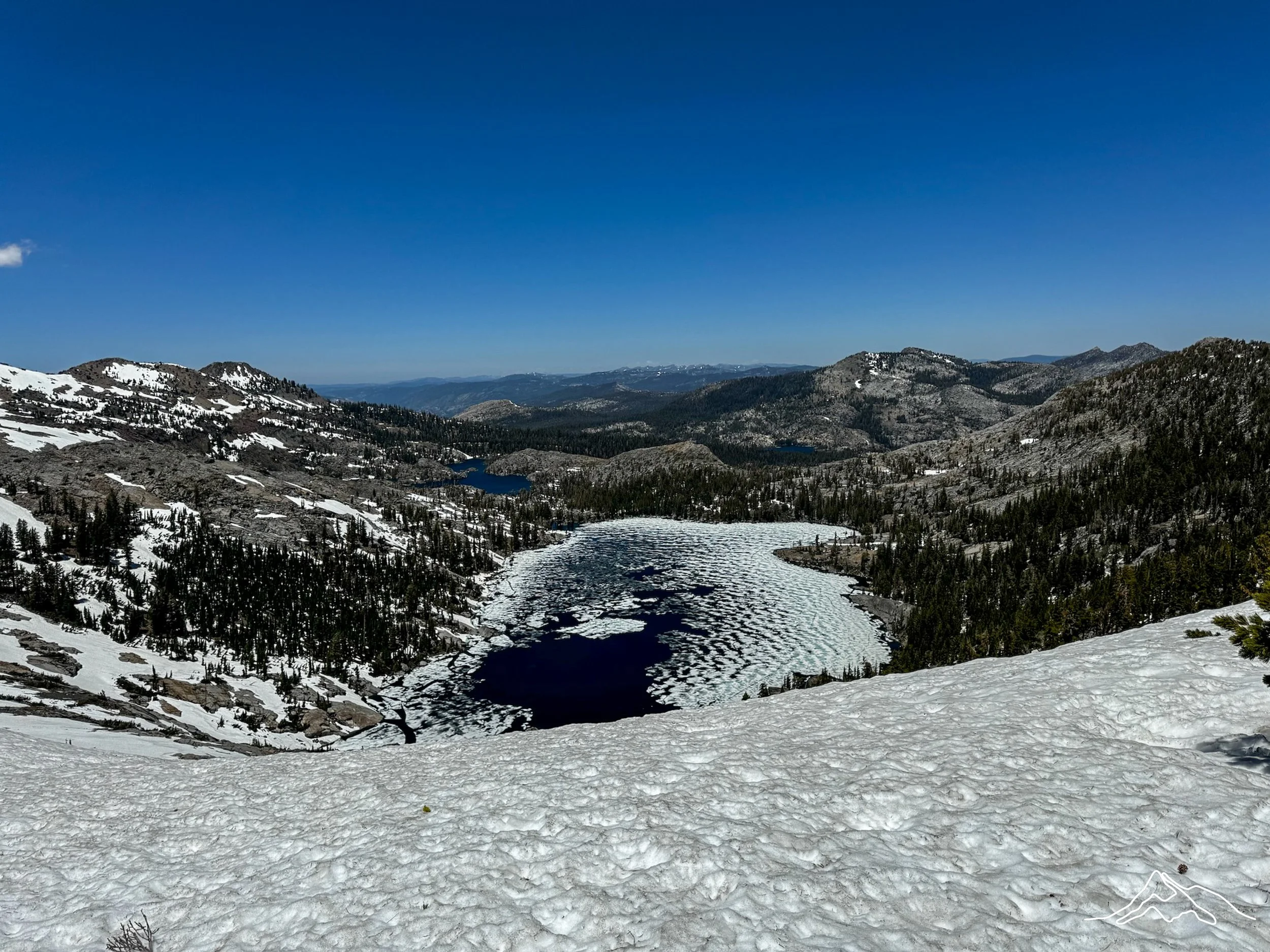
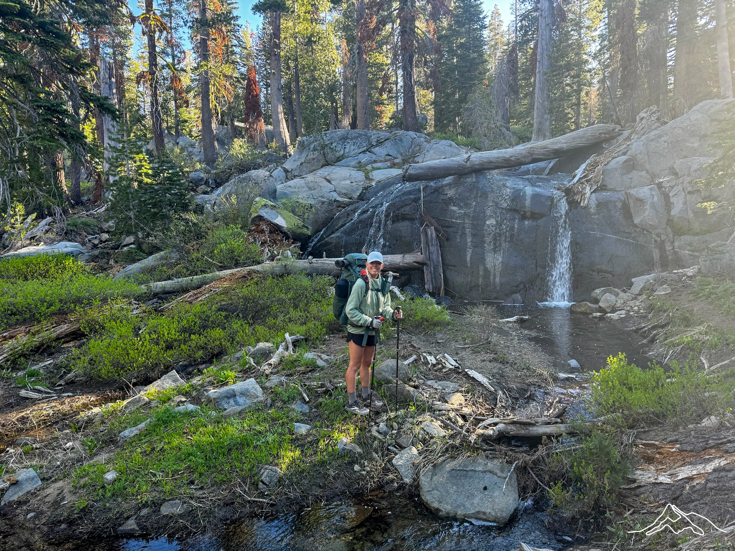
As I have mentioned in previous posts, the beginning of the Northern California section starts with the Desolation Wilderness. This is a relatively remote section of trail near Lake Tahoe. It is just over 20 miles long, but with a camping ban just beforehand, it makes it a mandatory 24 mile stretch that requires a bear can. Because I had my at-home support person joining me for this section, I was not planning to make it through in one day hence why I still had my bear can.
We got a ride to Echo Lake Chalets and began our day! Echo Lake was beautiful and started to provide views that I had described to my visitor, so it was nice to have them see a taste of what I had been lucky enough to see the past few months. There was an initial climb as we headed into the wilderness, but overall it was a moderate first half of the day with highlight views near Aloha Lake. I also crossed 1100 miles here which felt like an accomplishment.
About midday, we summited Dick’s Pass, which provided stunning views on both sides. This pass was still mostly covered in snow for the last 20%, which was a slight shock to my friend. Again, it was nice to share a bit of what my last month had been like in the High Sierra.
The descent towards Dick’s lake was also covered in snow, so we went from tree well (a snow free area around a base of a tree) to tree well. I was unable to find new microspikes in Tahoe, so I was still working with having just one foot of foot traction. Luckily my friend had the appropriate gear that made it a safe trek down the pass. Once we got down to the lake, it was a bit more snow free and offered beautiful views.
As we were approaching the 20 mile mark, we began looking for a spot to camp. Prick, Bags, and Yeti made it just past the border of the wilderness zone and we camped about 4 miles behind.
Overall it was a moderate hiking day for me but seeing the strenuous effort from my friend made me realize that I perhaps am/was more in shape than I realized. They are a very fast and accomplished marathon runner and I was not only able to keep up with them, but recover quickly and had the endurance to do even more miles. At camp, they took a nap while I completed some chores. An early bedtime was called for and we quickly passed out.
Day 86: Mile 1113.7 – ???
Trail Daily Miles: 13.7
Total Daily Miles: 21.9
Total Trail Mileage: ???
Elevation Gain: 2485 ft
Elevation Loss: 3563 ft
Weather: Sun
Overall Day Sentiment: Southbound? For safety.
We had a slow start to the morning which was in direct contrast to what I had been doing in the Sierra. While I was feeling okay after the day prior after resting in Tahoe for a few days, my friend was feeling every mile and foot of elevation gain. It was another great reminder of how I felt towards the beginning of the trail knowing (and dreading?) hiking while totally sore. It takes a few miles to warm up in the morning after an arduous day.
My friend and I quickly finished Desolation, which was definitely an accomplishment! The trail remained clear of snow (thank you, Northern California!) and we were able to get some solid miles in, though mosquitoes really started to make their appearance. At our lunch spot, we ran into several Tahoe Rim Trail (TRT) hikers and shared stories of our hiking experiences. One of the men had done this section of the TRT as his first backpacking trip – what a first time experience!
After lunch, we did a bit of climbing and crossed Barker Pass road. We continued to climb through beautiful fields of flowers up to a summit area that had small views of Lake Tahoe. On the descent from this high point, it became steep and snowy. Unlike the descent the day before, there were few tree wells and the snow seemed to continue on as far as the eye could see.
I had been doing these type of sketchy descents for over a month now so I didn’t think too much of it. My tolerance for scary hiking experiences in which I (literally) feared for my life had grown, while my friend had not experienced anything like this before. After some contemplation and having realistic conversations with ourselves about comfortability and skill level, we made the hard decision to turn back southbound and go to Barker Pass road.
The initial plan was to get my at home support person a ride from the trailhead down the 8 mile road to Tahoe City and then they would figure out logistics while I continued on. After calling a slew of trail angels with no luck for a ride, we headed down the 8 mile paved road. Turns out, the road was still closed for the season after seeing many downed trees and rockslides covering the road.
This was a hard 8 miles not only because walking on pavement with a heavy pack on is painful, but because for the first time I had to head southbound (rather than northbound) and make a conscious decision to head away from the trail. But because it was a matter of safety for my hiking partner, that provided some solace. It also once again reminded me of how much I had grown over the course of the hike thus far.
Once we got down the mountain, we headed into Tahoe City which was a wonderful, cute town! I ended up liking it more than South Lake Tahoe as it was walkable and more accessible than the former. We had a fantastic dinner and made a plan for the next few days.
Day 87: Mile ???
Trail Daily Miles: 0
Total Daily Miles: 0
Total Trail Mileage:
Elevation Gain: 0
Elevation Loss: 0
Weather: Sun
Overall Day Sentiment: Thankful for non-trail and trail friends.
With a solid plan moving forward to get my friend back home and me back on the trail heading northbound, we were able to enjoy a delicious breakfast in Tahoe City. There is great public transport in the area and we caught a free bus to the Truckee area. This bus also went through the Olympic Village area from the 1960 Winter Olympics. My visitor was heading to Reno by way of Truckee while I would get a ride up to Donner Pass (yes, that Donner Pass/party).
I made it back to the trail at Donner Pass and spent the afternoon at Donner Ski Ranch. This is a hiker highlight because they give out a free beer to all PCT hikers! There was about 20 hikers there trickling in and out throughout the day. Prick and Bags were going to make it there in the evening so Yeti and I hung out for the day waiting to have dinner with them.
There are accommodations on site in the form of dorm rooms. In the winter, these dorm rooms are meant for skiers in the area, but are used for hikers in the summer. I stayed overnight at these dorms, though got mediocre sleep, with the goal of setting out early in the morning with the reassembled crew after an unplanned zero!
Day 88: Mile 1154.5 – 1173.6
Trail Daily Miles: 19.1
Total Daily Miles: 19.2
Total Trail Mileage: 1173.6
Elevation Gain: 3314 ft
Elevation Loss: 2566 ft
Weather: Sun
Overall Day Sentiment: Northern California is feeling good so far.
After an early wake up, we hit the trail and were delighted to see that it was mostly snow free for the first portion. This part of the trail crossed i80, a major highway, in which I had to go through a few culverts. As I would also soon discover, the trend in Northern California would be a large climb when coming out of a city. This was smaller than what I would tackle later on, but a climb nevertheless.
I did end up hitting snow throughout the day, mostly in forested areas. Much like I’ve described before, the snow was in snow drifts which are always *fun to climb up. In one of the forested areas, we stumbled upon Peter Grubb hut which is a small shelter from the Sierra Club. The door was not open, despite my best attempts to climb the exterior ladder and go in through a window, I did not get in.
*not fun at all.
In contrast to the forested areas, there were also expansive views the mountains both to come (smaller and snow free) and mountains had gone (snow capped peaks). We all camped in the same spot that night near a road along with a Father and Son duo that had just started out that day (Dizzo and Squints) – and we continue to run into them to this day!
Day 89: Mile 1173.6 – 1196.5
Trail Daily Miles: 23.9
Total Daily Miles: 24.3
Total Trail Mileage: 1196.5
Elevation Gain: 2437 ft
Elevation Loss: 5500 ft
Weather: Sun
Overall Day Sentiment: Still cautiously optimistic about NorCal.
The day started with a decent climb that came up from the road. The climb was through the trees but the ridge that I eventually ended up on had initial views of Mount Lassen! The Cascade Mountain range is volcanic therefore has created some tall mountains that splatter the landscape (read: not mountains but volcanoes). Mount Lassen would be the first of many for us to see.
This day continued the same pattern as the day before for a bit; rolling inclines (cue good views and giant boulders to hide behind and scare unsuspecting hikers) followed by descents (cue the snow drifts in the forest that were easy to fall up) There were a few snow traverses this day, though microspikes were not necessary.
The goal of the day was to head into Sierra City as it is a classic stop along the way but also because I had a resupply package there. There was a steep ridge descent into town which first lead you over a bridge. The bridge, Loves Bridge, had been damaged by a tree in a recent storm, but was still passable.
After a quick 1.5 mile road walk into town, I received my resupply package (which would turn out to be a debacle, but that is for the next post) and had some snacks in the hiker area that they have set up outside of the general store. I stayed at the Old Sierra City Hotel for the night – a shower is always a gift. But was there soap in the bathroom at all, even to wash your hands? Lower your expectations.
xoxo Kanga/Leeann