Appalachian Trail Hike: Maine (Part 2) - Mile 2083 - 2197
Appalachian Trail Hike: Maine (Part 2) - Mile 2083 - 2197
The Appalachian Trail complete. Wow. When I completed the Pacific Crest Trail, I never thought I would do another long long distance trail. But when life continued to throw a mountain worth of lemons at me, I decided to hike up it.
My goal was 100 days to complete the AT, but I landed at 103 days with my finish date being July 12th, 2025.
I’m thankful to everyone I met, who supported me on or off the trail, those that believed in me, and to those that listened to me in my moments of struggle. That is the real trail magic.
Appalachian Trail Hike: Maine Summary
Statistics:
Days: 5
Full hiking days: 5
Zeroes: 0
Neros: 0
Total Trail Miles Covered: 122.3
Total Elevation Gain: 22,806 ft
Total Elevation Loss: 22478 ft
Highlights:
Finishing the Appalachian Trail.
Completing my version of the trail in 103 days.
Lowlights:
100-mile Wilderness was beautiful, but still difficult and not actually that wild?
Heat, humidity, and bugs were ever present.
A strange trail family throughout this entire section.
What’s next?
Appalachian Trail Hike: Maine Detailed Version
Day 99: Mile 2083.8 - 2103.2
Trail Daily Miles: 19.4
Elevation Gain: 4622 ft
Elevation Loss: 3422 ft
Weather: Sun, Hot, Bugs
Overall Day Sentiment: The Cloud Pond shriek heard for miles.
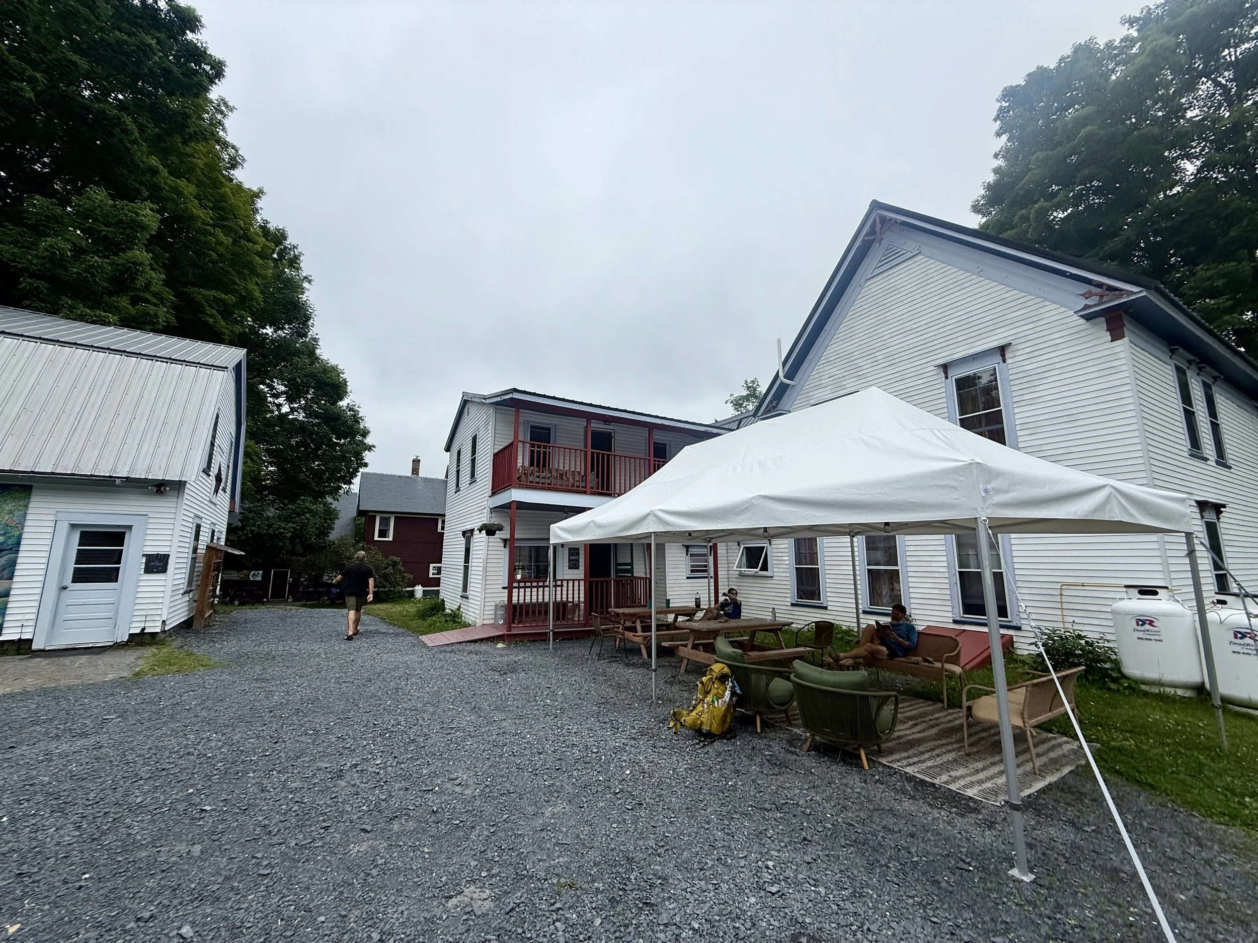
Waking up at Shaw‘s I was filled with both excitement and trepidation for the five days ahead. Now with my flights booked, I had a limited amount of days left to finish the trail.
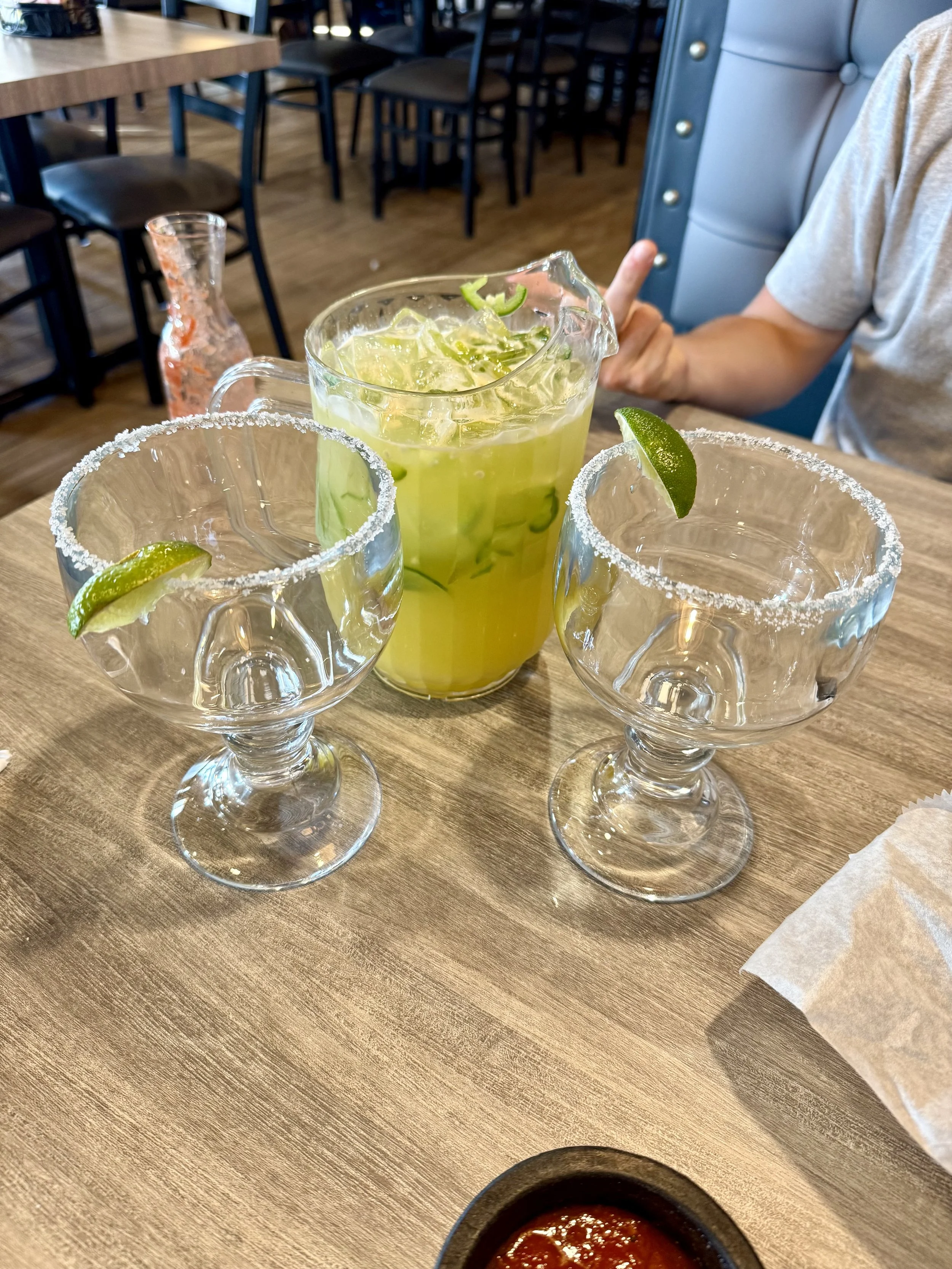
Shaw’s Hiker Hostel is known for a fantastic giant breakfast that they offer. Breakfast is my favorite meal so obviously I signed up for that. George and I dined with Hydro, Thumper, and Seconds. I watched Seconds really try to take the unlimited pancakes as a personal challenge, which was fun to see - especially after he put on “Eye of the Tiger” to motivate the last few bites. After eating a full breakfast and consuming much caffeine via coffee - my bag was packed as hopped in the shuttle back to the trailhead.
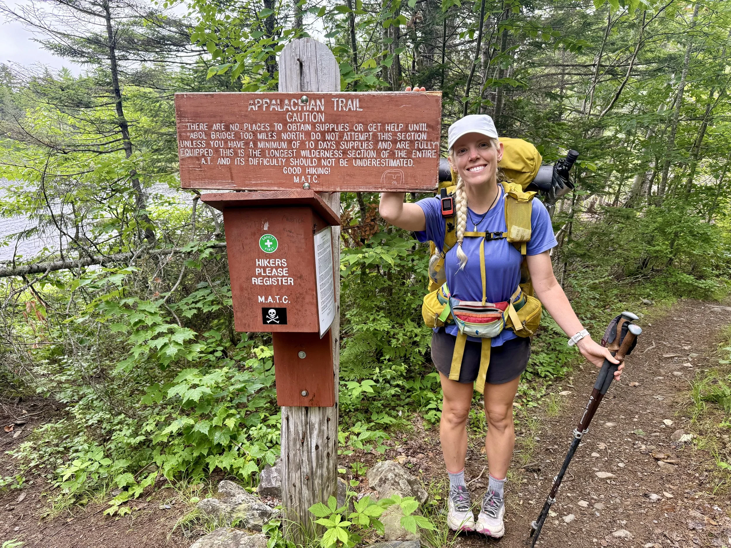
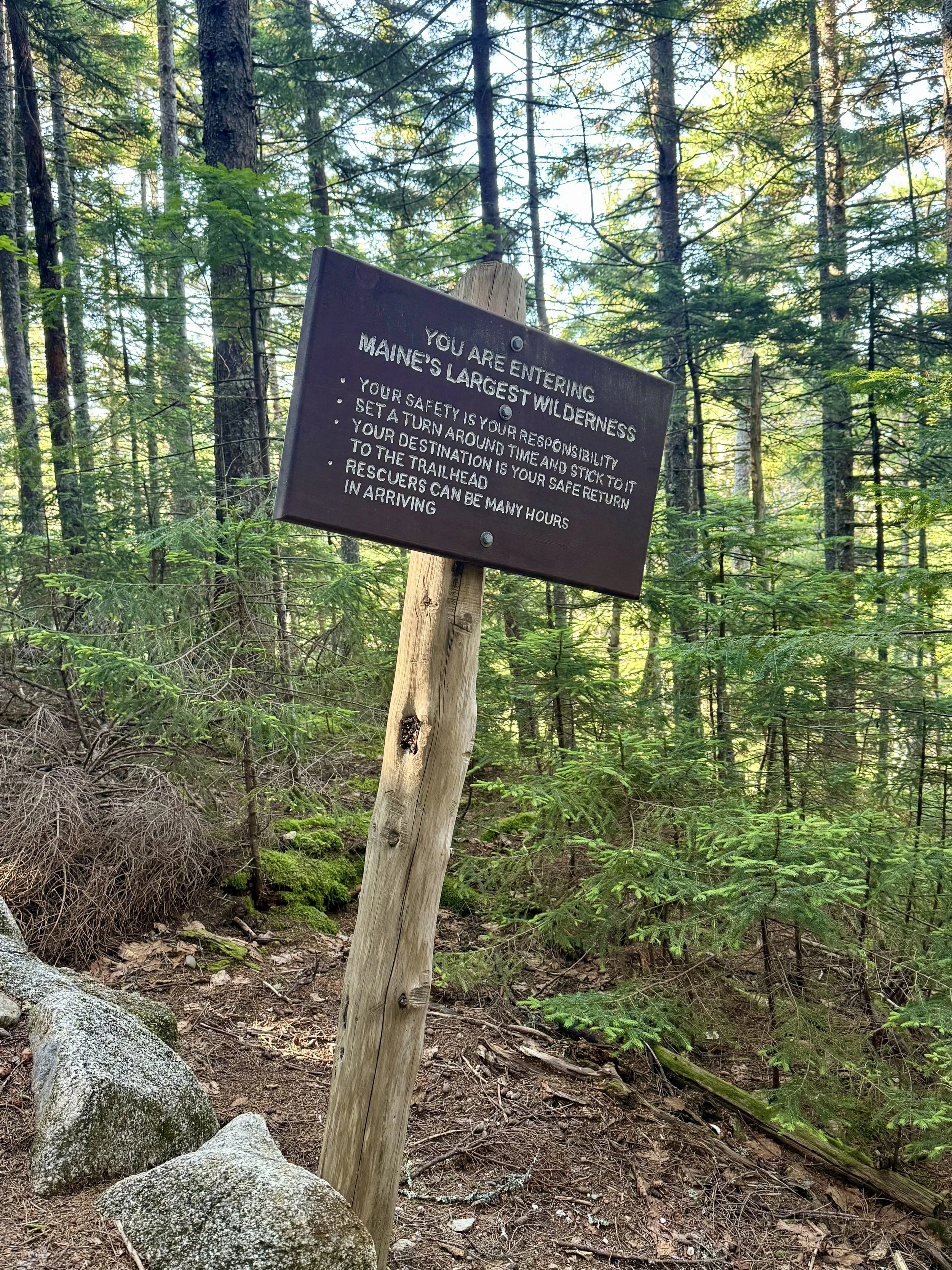
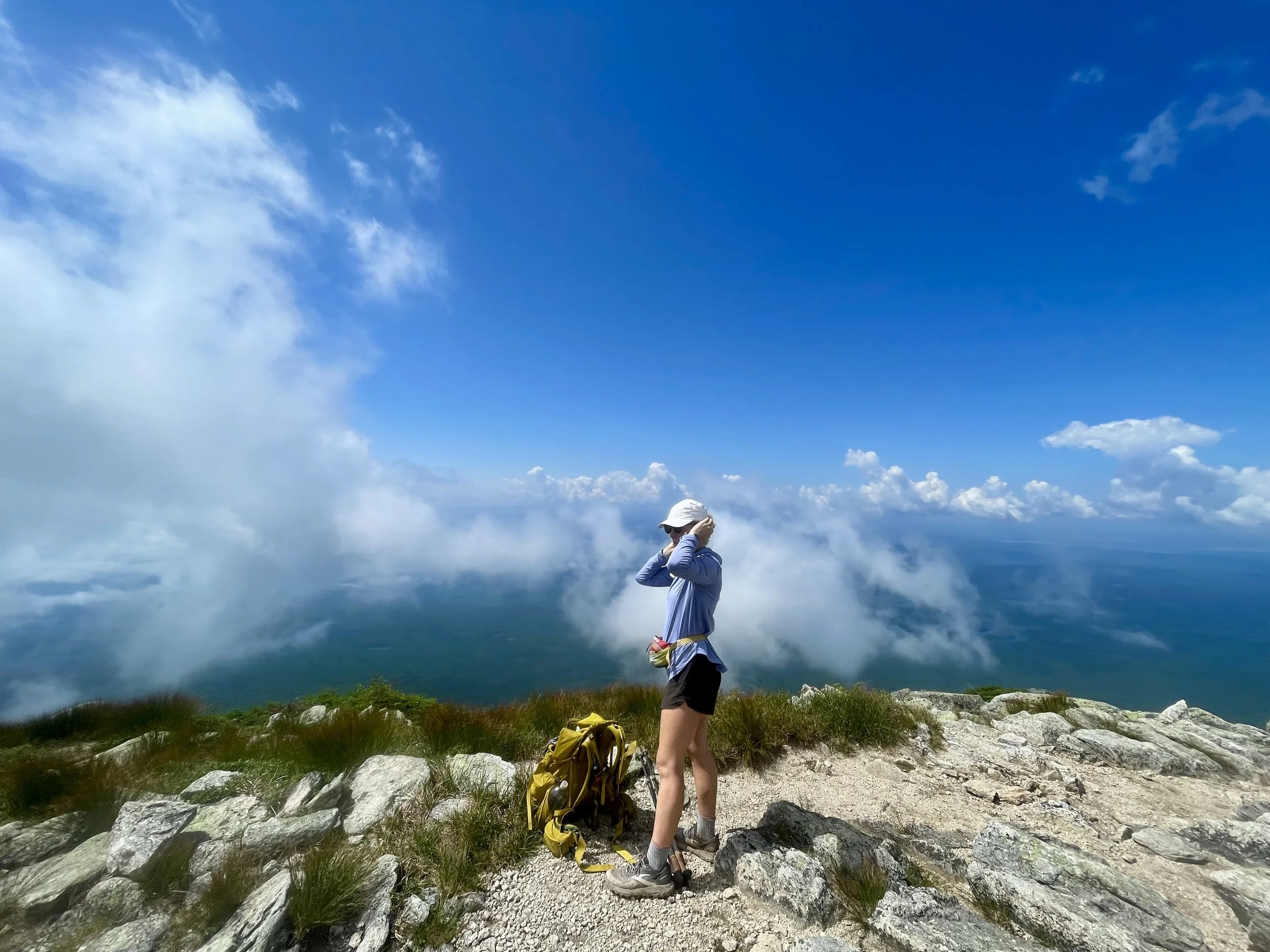
As Poet dropped us off he recited a beautiful poem – my guess would be this is why his trail name is poet. I’m not typically one who cares for poetry, but he had me tearing up and getting verklempt as I was taking off for the day. It was a lovely send off as I was heading into the wilderness. The 100-mile wilderness is supposedly one of the most remote places along the entire Appalachian Trail. There is a sign (pictured below) that says in order to tackle the 100-mile wilderness, it is recommended that you have 10 days worth of supplies. George and I were planning to do this in only four days which gave me a little bit more apprehension for entering.
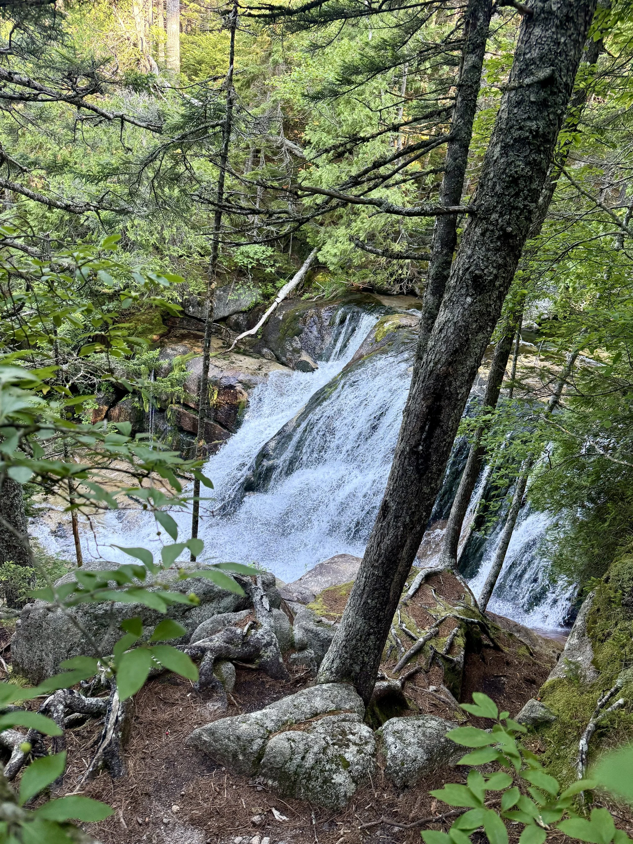
The 100-mile wilderness has been talked about for much of trail similar to the White Mountains of New Hampshire. It was mentioned that it was flat relative to the rest of the trail. This was my first mistake, trusting anyone who had done the Appalachian Trail in the past to give me any insight to what the trail actually looks like. It was not flat.
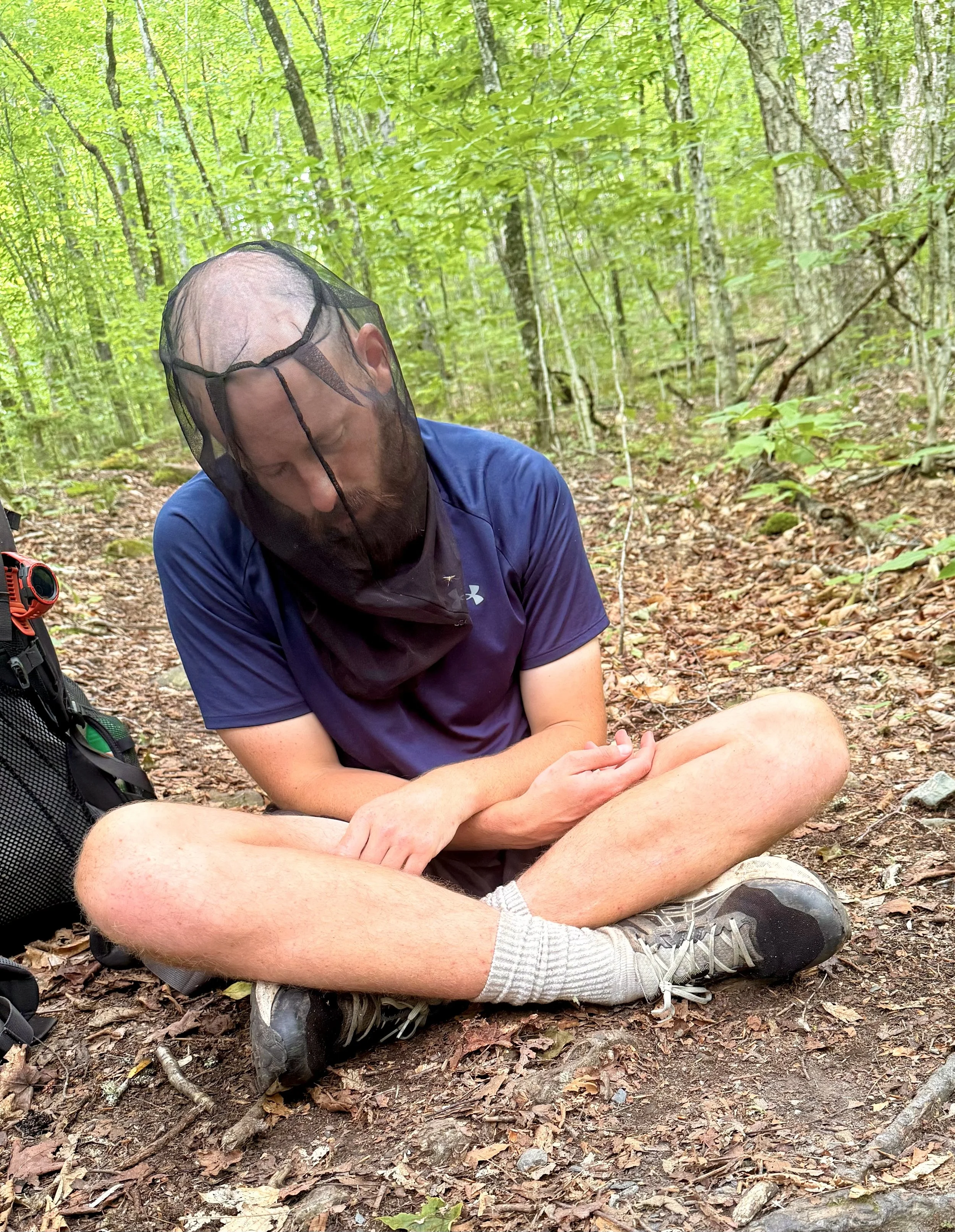
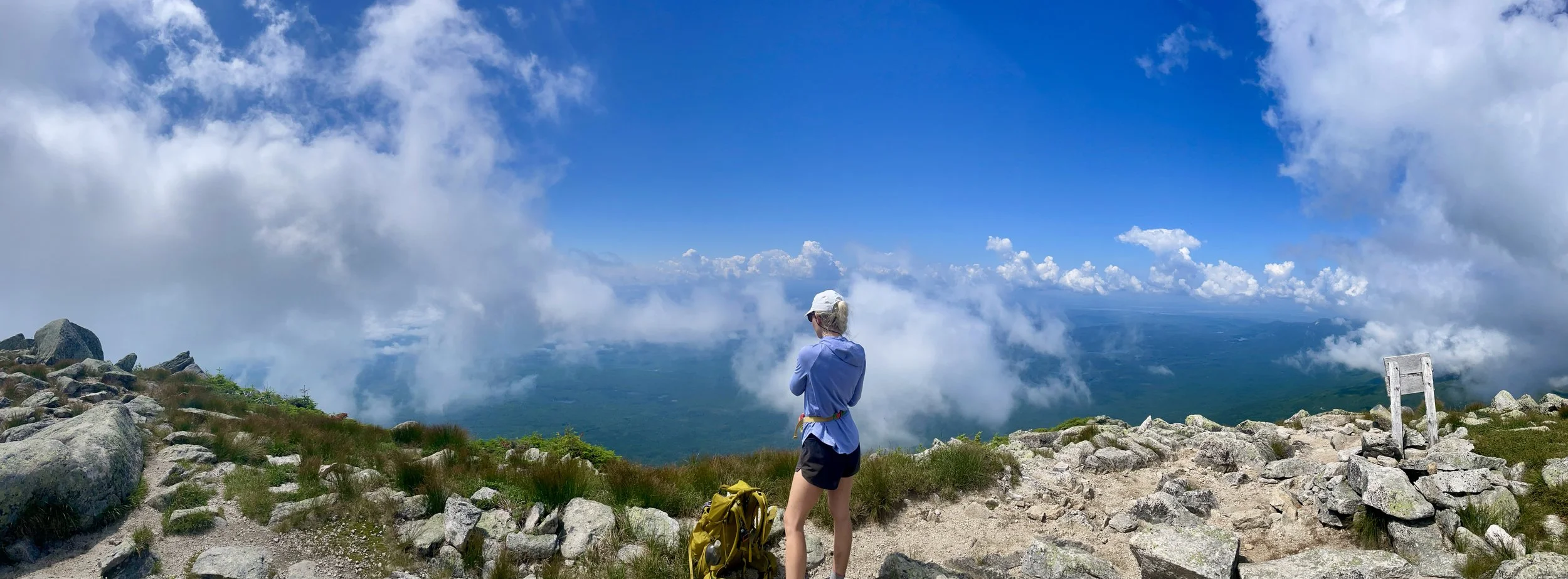
George and I tried to hike together most of the day to get to a sheltered area on Cloud Pond. It was just over 19 miles away and with the intel of it “being flat“, I was not prepared for such an arduous day. At one point we stopped for a snack and because I was not feeling particularly well, and George fell asleep sitting up with his mosquito now on (also pictured below).
Just before the shelter area there was a final climb up Barren Mountain. I was so tired from the day that I started talking to myself aloud. Saying some wild things about this one mountain in particular. It sounded like in auditory diary of an absolutely mad woman. Poor George.
The shelter was quite a bit off trail, and though I was hoping for a nice clear path to get there, it was all rocks, roots, and wobbly wooden planks. On this day, I had fallen more than usual whether that just be a little trip, stumble, or a full fall. On one of these planks, it wobbled me right into a tree and down I went. My last nerve snapped at that very moment. I screamed so loud I am unsure where this volume physically came from. And of course, because the shelter was right near a lake…the echo made it all the more dramatic. I heard an “Are you okay?” from the distance and realized that I was closer to the shelter area than I initially thought.
I walked up only a bit further and found a large group of hikers sitting having dinner with stunned eyes. I apologized for my scream and noted that I had fallen nearly 50 times that day and although they said that they understood, the assessing look in their eyes said otherwise. I set up camp for the night and even though George had been directly behind me when I shrieked, he arrived to camp about five minutes later. He did this because he was embarrassed to be seen with me. Oops!
The pond/lake was beautiful so I took a dip before I tucked into my tent for the night. I really hoped the rest of the 100-mile wilderness was not like this.
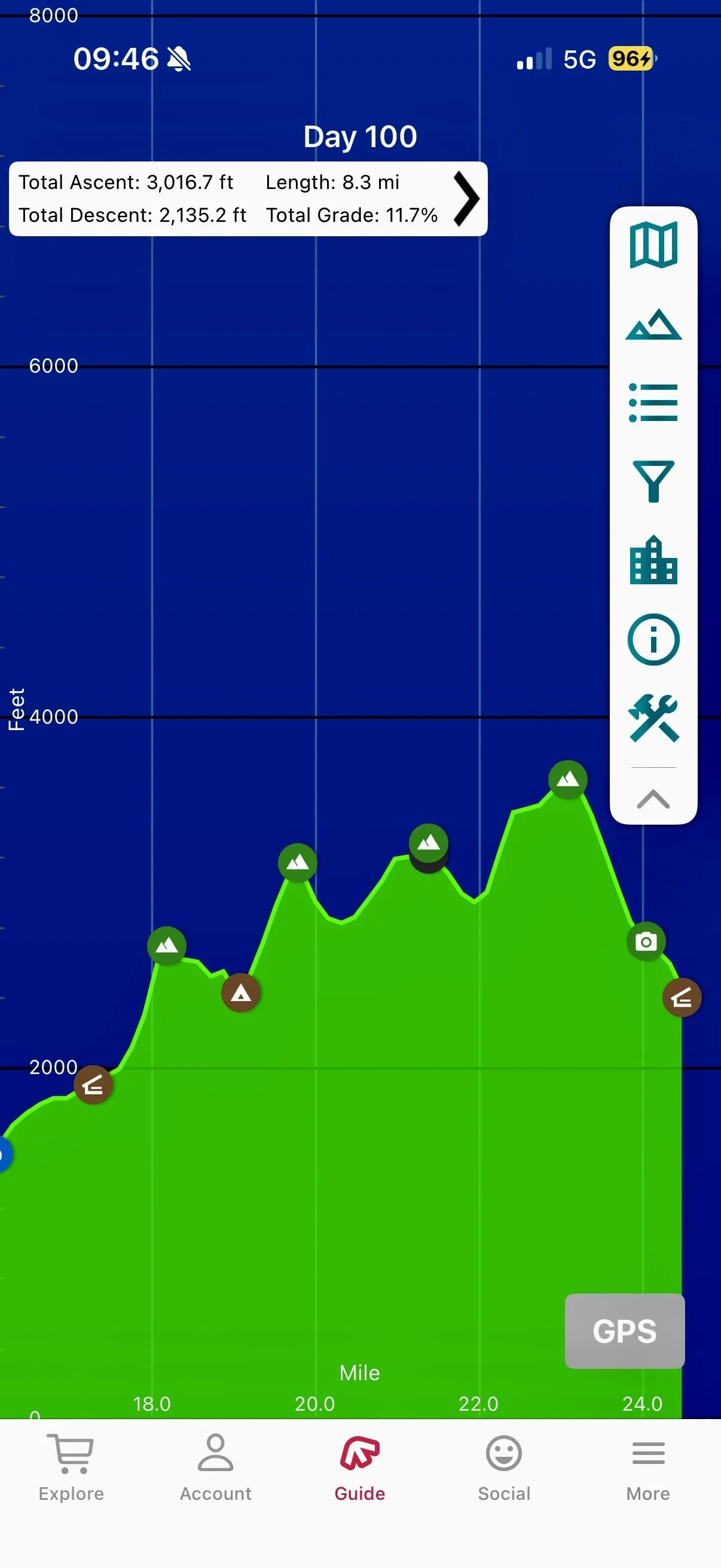
Day 100: Mile 2103.2 - 2127.7
Trail Daily Miles: 24.5
Elevation Gain: 7116 ft
Elevation Loss: 6081 ft
Weather: Sun, Hot, Humid
Overall Day Sentiment: How much elevation gain?
Waking up for my second day in the 100-mile wilderness, we had a decent size day ahead of us. Again, despite being told it was flat, I was looking at over 6000 feet of gain for the day. George and I left early and decided to hike together again for a bit to try and pass the time. There was a steep decent straight away which is always brutal to start the day with. Anytime I’m going down steep rock decent. I always like the person behind me to be ample distance away from me in case someone slips. On this particular morning, I am glad that that was my rule as George slipped and tumbled down several rocks nearly running right into me even though I was 12 feet in front of him. It was a pretty serious fall, even though he downplayed it.
The group from the night before that had commented on my scream was also coming down this descent at the exact time that George fell. This was a trail family of five and we would continue to bump into them all the way until the end. Individually, they were nice and chatted with us, but as a group it felt like no one was allowed to talk outside their group – it was a very strange dynamic.
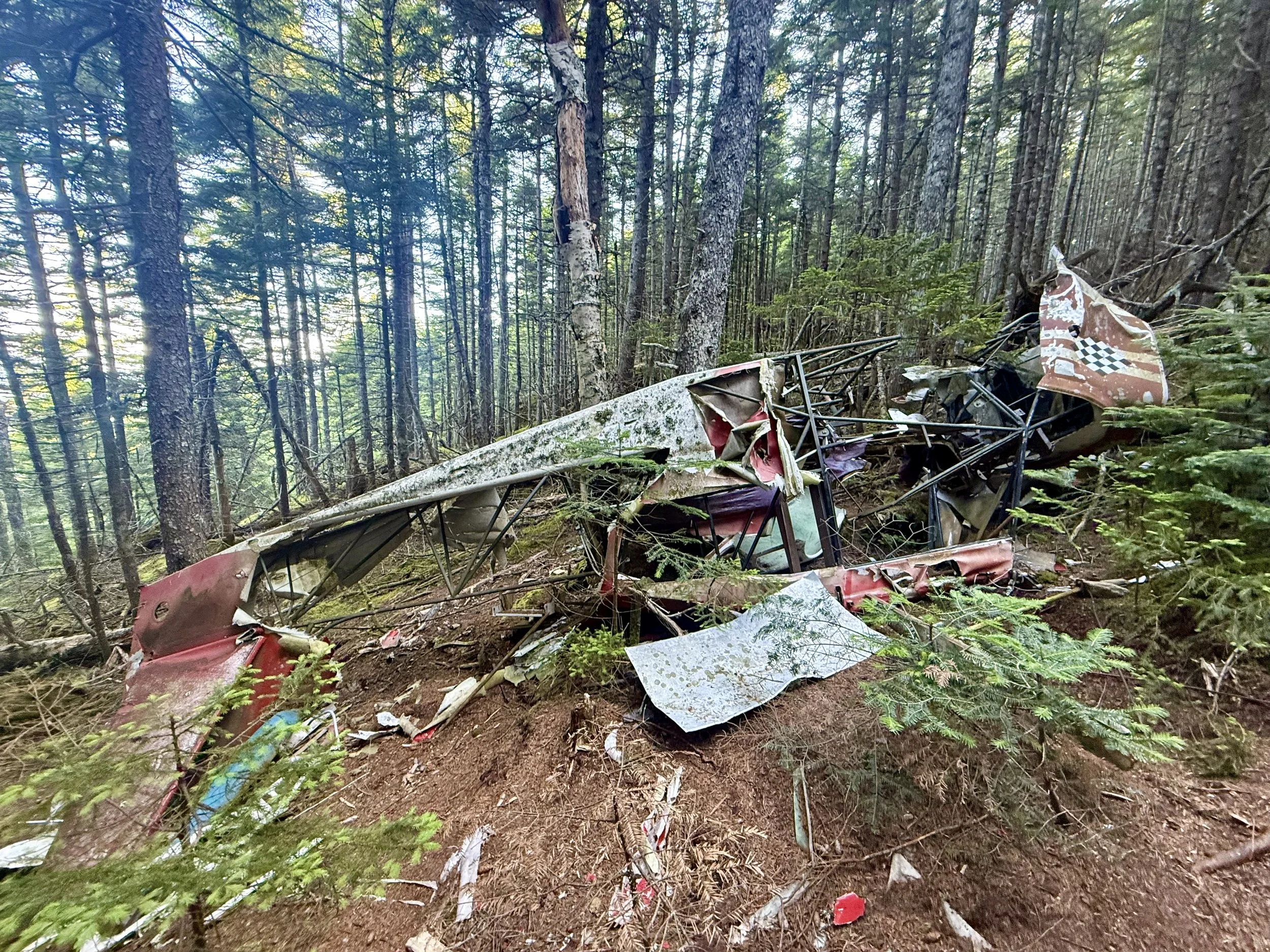
While George regrouped from his fall, his arm was definitely going to be bruised. There was a small plane wreck that was near to the trail, which was interesting to see in particular because everyone survived. George got behind me a bit and I took a wrong turn that lasted all of one minute and that was the end of us hiking together for the day. Because I am a substantially slower hiker than George - that one minute - separated us for the remainder of the day.
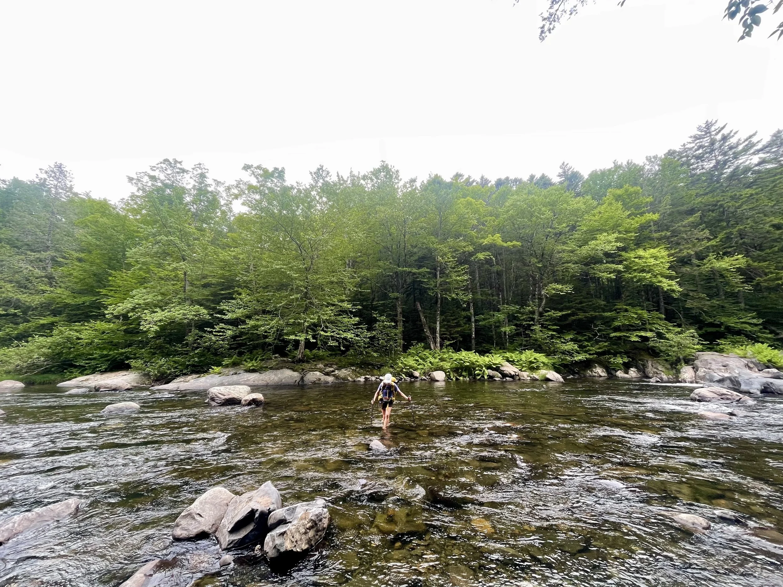
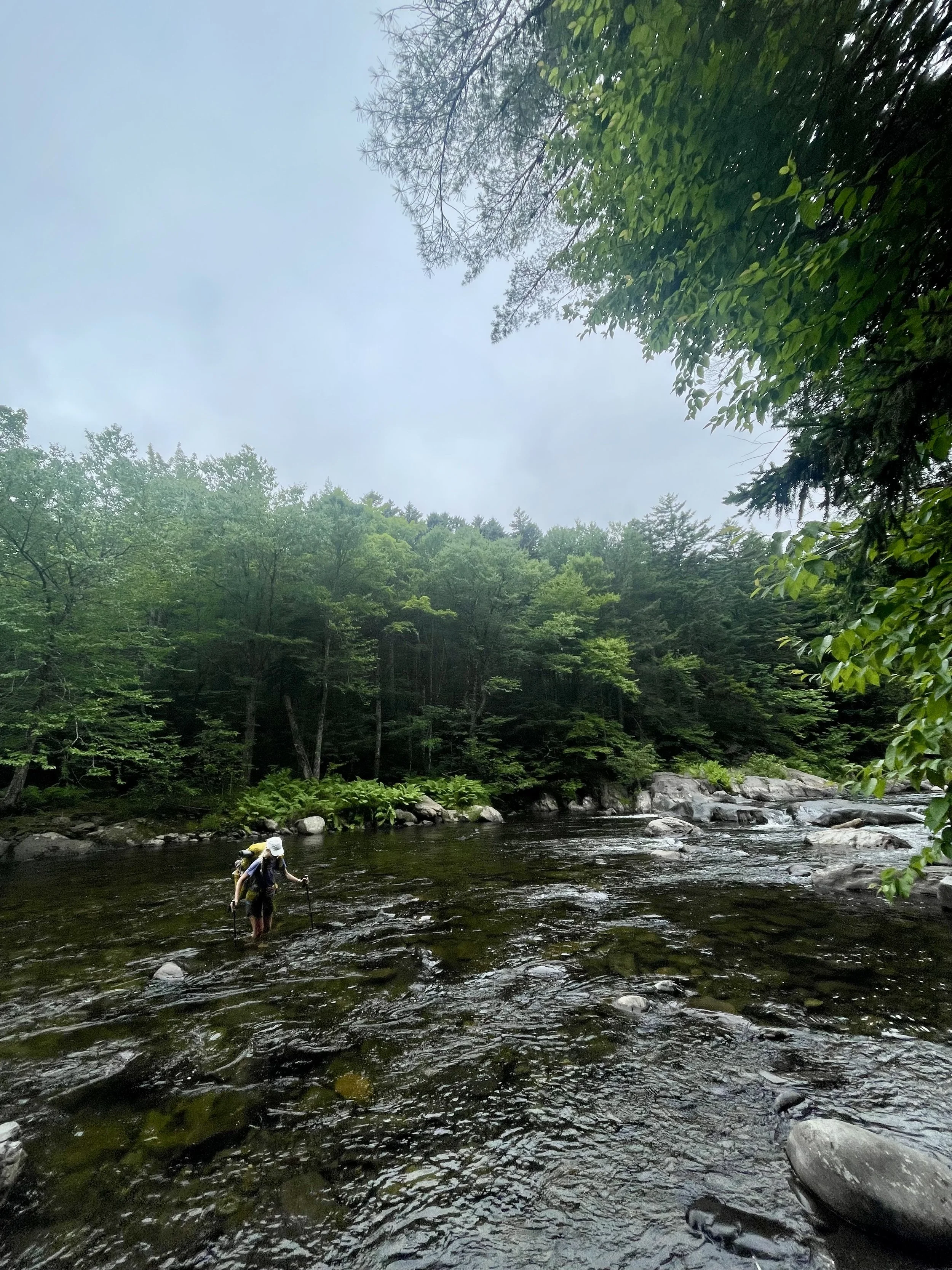
There were a couple river crossings on this day with one larger one, a very shallow wide river. Once I got across this river, I decided to sit down and have a proper lunch. This was also the last stop before the substantial climbs that were on the back half of the day. I was having lunch with another thru-hiker when a family of four walked by. They did not have full backpacks as they were out just for the day. My assumption when something is labeled the “100-mile Wilderness” is that it is in fact wilderness. Turns out there was a parking lot close where people can come in day hike and stay at lodges nearby. The illusion of complete wilderness was broken for me there and I realized once I looked at the map, how many logging roads and parking areas that we were going to be near or crossing.This family was kind, asked us a lot of questions, gave us a few snacks, and then took our trash. It was a dream, and I was very thankful to run into them.
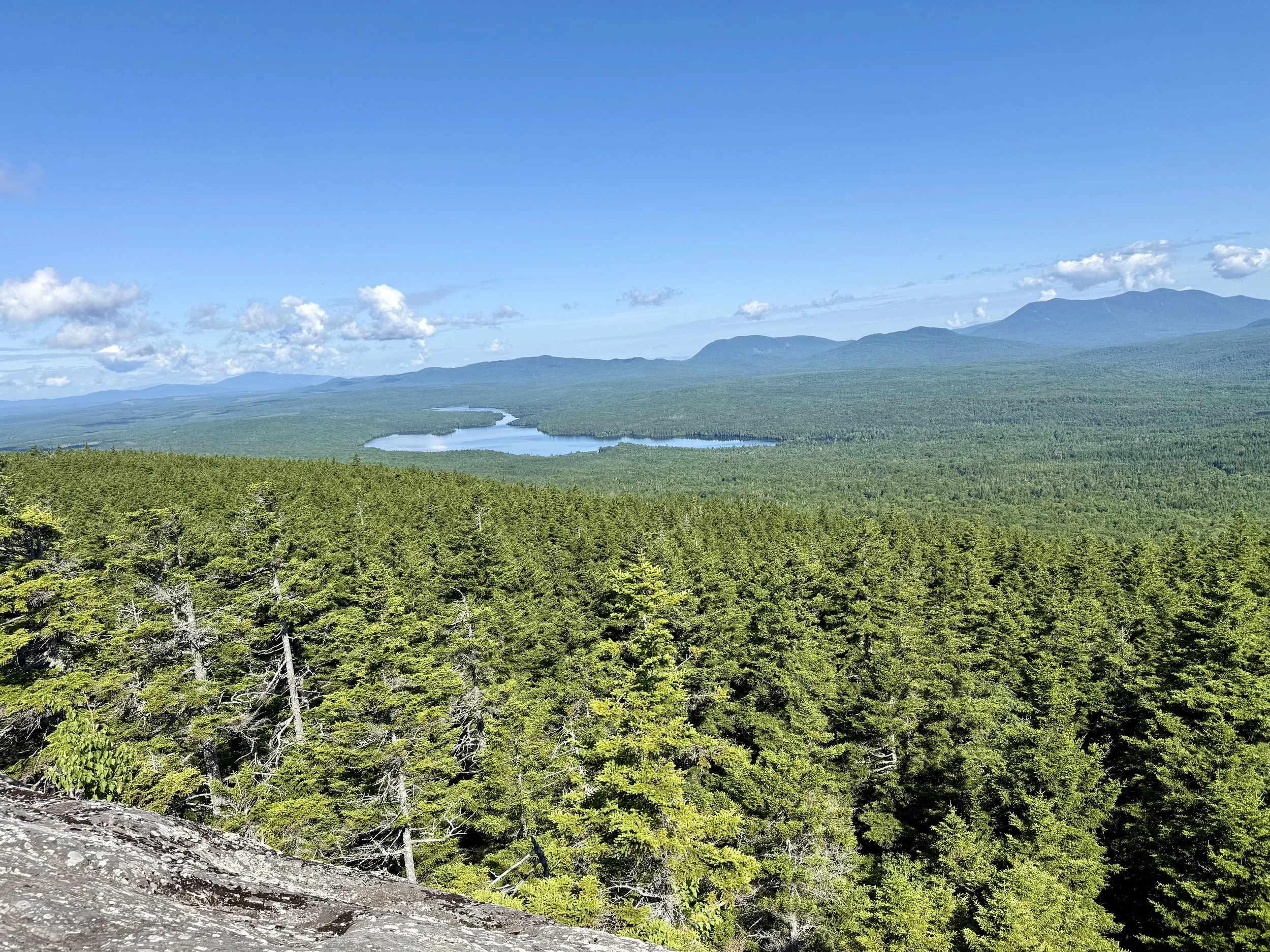
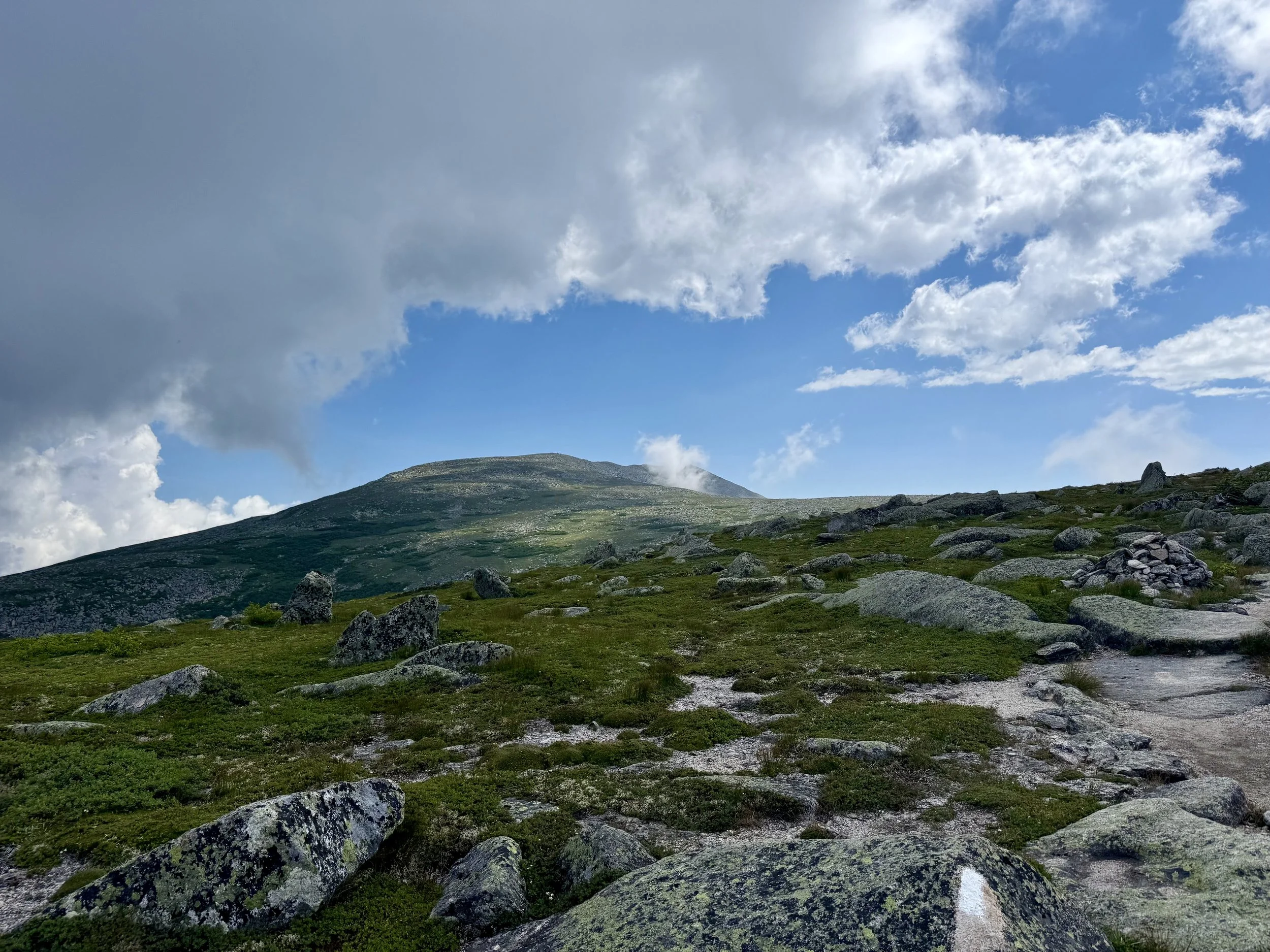
The first bit of climbing was very gradual along a beautiful river in a canyon. Then I got to a section of the trail that was comically a roller coaster – I have included a picture below for you all. The final climb was up White Cap Mountain and this is where you get the first views of Mount Katahdin. Mount Katahdin is the Northern terminus of the Appalachian Trail. It was a bit overwhelming emotionally to see the physical end of the Appalachian Trail, more than was expected for me
It was getting pretty late in the day and the sun was beginning to set as I made the final descent into the shelter area. The shelter area was pretty small and there were several other hikers there, including George, and including that trail family of five from the night prior. I set up my tent on one of the lumpiest sites I have ever camped on, got water, and changed into my sleeping clothes. The the top of my butt had been hurting and because of the heat and humidity, I knew that I had terrible chafe from where my backpack sat on my glutes. This was confirmed when I changed and I had complete open wounds on my butt. So the evening consisted of me laying face down eating dinner and letting my wounds air out with some antibiotic ointment on them.
And though FarOut (the mapping application) said that the day was only slated have about 6200 feet of elevation gain – my Garmin watch tracked over 7000 feet. I can understand a 10% disparity but over 1000 feet difference really does make a difference in how my legs are feeling.
By the time I actually fell asleep it was roughly 10:30pm and I had a 5:15am wake up call to get the miles I needed to be done for the day the following day. I was tired in my bones.
Day 101: Mile 2127.7 - 2158.3
Trail Daily Miles: 30.6
Elevation Gain: 2160 ft
Elevation Loss: 3985 ft
Weather: Sun
Overall Day Sentiment: So tired.
When my alarm went off, I just started crying. I was tired, not only from only a few hours of sleep, but just deep tired from this trail. I was hoping at this point I would start to get butterflies thinking about the finish or start to be sad about leaving the trail, but I was just ready for at least a week of sleep. My chafe on my glutes overnight had not healed much at all so I knew the day was going to be somewhat painful with my pack balancing on this still open wound.
This day was supposedly going to be much flatter and luckily it was. There was several miles of flat along the river where George and I were able to really do some quicker miles. This was the flattest of all of the days in the wilderness area so I wanted to get a big mileage day in to make the following day a bit easier.
This day was just kind of a chugging along day and cranking out some miles. With about 7 miles to go, George left me and was going to get a spot at our decided upon area, which was put us at just about 31 miles for the day. All was going fine until the last 3 miles where the footing degraded, I kept losing the trail, the roots covering the trail were comically placed and it put a damper on a relatively good day.
I got to the lake that we were camping on and there were several other groups there. Several other groups of hikers but not just thru-hikers but car campers. So again this 100-mile wilderness was very accessible by car.
George was already set up so I set up my tent near his, took a dip in the lake, made dinner. The other trail family was also here again and barely spoke to us – I’m unsure why trail families and people at this point in the hike don’t want to connect with anybody, it does not make sense to me.
It was another late night and it was dark by the time I had wrapped up my chores for the evening, but it was a shorter day the following day so I was hopeful for some sleep.
Day 102: Mile 2158.3 - 2184.1
Trail Daily Miles: 25.8
Elevation Gain: 3416 ft
Elevation Loss: 3498 ft
Weather: Sun, Hot, Bugs
Overall Day Sentiment: Last full hiking day on the AT!
It was an early start of the day again, but this was our last full day of complete forward progress on the Appalachian Trail. The goal for the day was to get to our last campsite before Mount Katadhin.
George and I hiked together again for the majority of the day. I think he chose to hike a lot of this last section with me because he knew that I was hanging on by a thread, which I sincerely appreciated. There was not too much elevation gain this day, though there was a bit more than our day before.
With about 11 miles to go, George and I had lunch at a beautiful at Rainbow Stream, which was situated next to the aforementioned stream. Sitting here eating snacks, knowing that I would finish the Appalachian Trail the following day with my trail companion who I met night one it was special. We decided that he should go ahead and get our campsite situated at Abol Bridge campground.
There’s a lot of confusion and fear mongering about how to get up and down Mount Katahdin and where you should camp in situate yourself in the best possible position.There is a shelter exclusively for thru-hikers, but they only allow 12 people to camp there and the sign-up sheet opens at 7:00am. Many people along the trail made it seem like if you are not waiting at 7:00am to sign up for the current night, then you are going to be delayed a whole day and summit a day behind. I did not want to mess with this so we camped out a bit further at Abol bridge. Flights were booked, so I had to finish.
The remainder of the day went somewhat smoothly. I ran into Princess Peach who I had a wonderful experience with back in Virginia and she was flipping her hike and heading southbound. It was invigorating to see a familiar face and get some Intel on Mount Katahdin from someone that I trusted.
I grabbed another snack near one of the only reliable water sources for the day and the trail family of five was there. As I approached, I heard “Did George and Kanga even start at Springer Mountain?” It was a strange and very high school feeling to stumble upon someone talking ill about you. Much to their surprise, I informed the group, “Yes we started at Springer on April 1 and are summitting tomorrow.” There was not much else to say but again it was such a strange dynamic! I’m wondering if because they had seen my long hiking hours and how obvious it was. That I was struggling in this section to think that I couldn’t make it from Springer Mountain, especially in a short timeframe. But if this trail taught me one thing it’s that I will put in the work, time, and effort to get it done, even if that means that I don’t sleep much.
The rest of the hiking day went smoothly. There were some great views in the Rainbow Ledges area and when I finally popped out onto the road walk to Abol bridge I was a bit overcome with emotion. I could see Mount Katadhin very clearly and I knew that that was my destination for the following day. I got to the campsite where George was already set up and had gotten us some snacks. I took a shower at the campground, which was nice after some sweaty days and to help with my chafe/wound situation.
I felt like a new woman – I was positive, giggly, and excited for the following day.
Day 103: Mile 2184.1 - 2197 - 2184.1
Trail Daily Miles: 22
Elevation Gain: 5492 ft
Elevation Loss: 5492 ft
Weather: Sun
Overall Day Sentiment: I finished the Appalachian Trail.
Today was the day that I was going to finish the Appalachian Trail.
It was an early departure time of 4:30am because there was a significant amount of elevation gain and technical hiking to get up to the summit. I had gotten two nights at Abol Bridge so I was able to leave my tent, sleep system, and any extras that I did not need for a day hike back at camp. A slackpack.
It was an easy start to the day and George and I eventually got to the previously mentioned shelter area that only holds 12 thru-hikers. Much to our surprise there were no hikers there the night before which meant we could’ve been a few miles closer, but alas, those were the cards to have been dealt.
When I got to Katadhin Stream campground area in trailhead, it was inundated with day hikers and weekend campers. My summit day was Saturday, July 12, 2025 and it was a beautiful summer Saturday so this is what I should’ve expected. It was unfortunately too early for the Ranger station to be open for me to get my summit number.
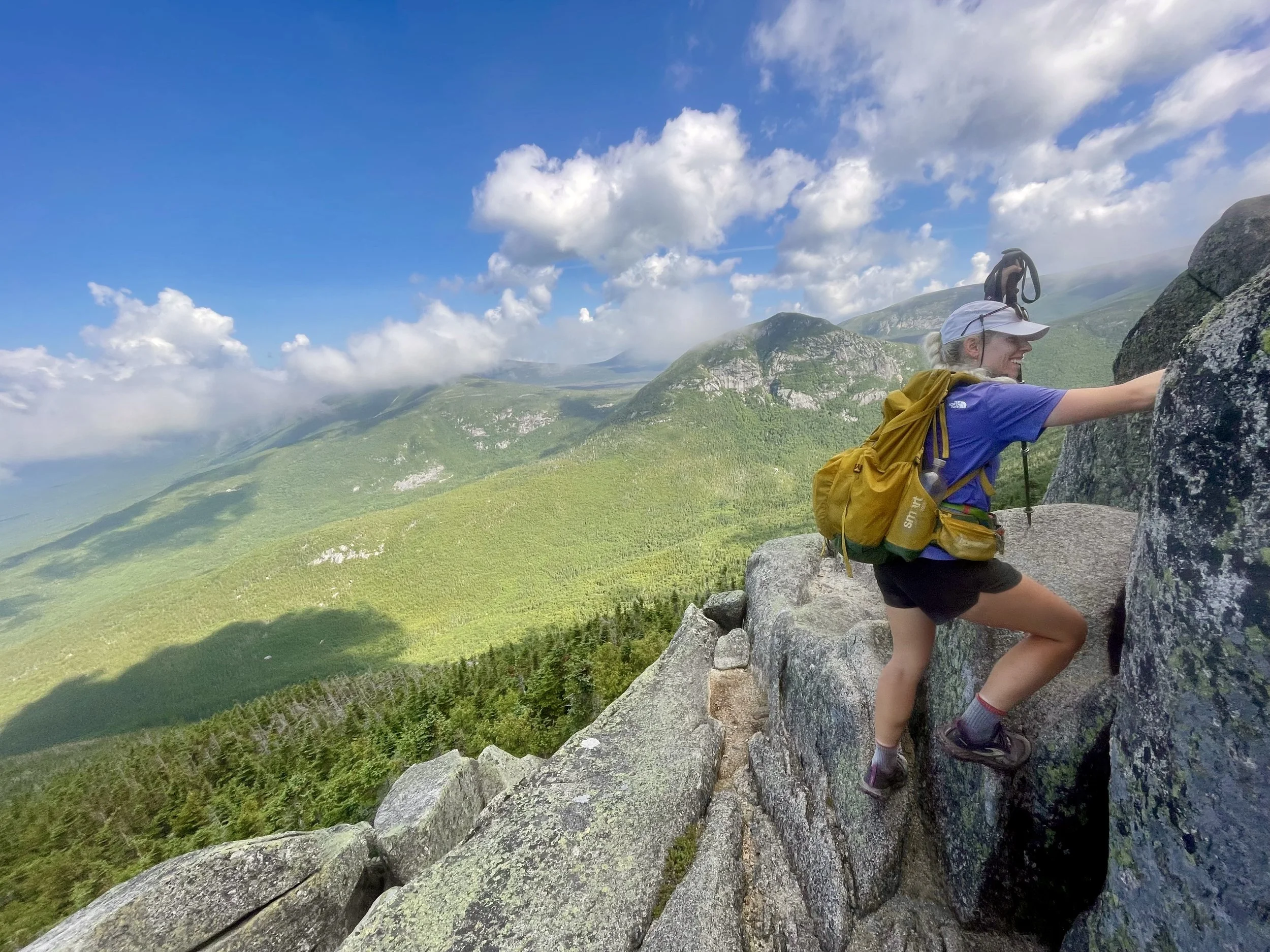
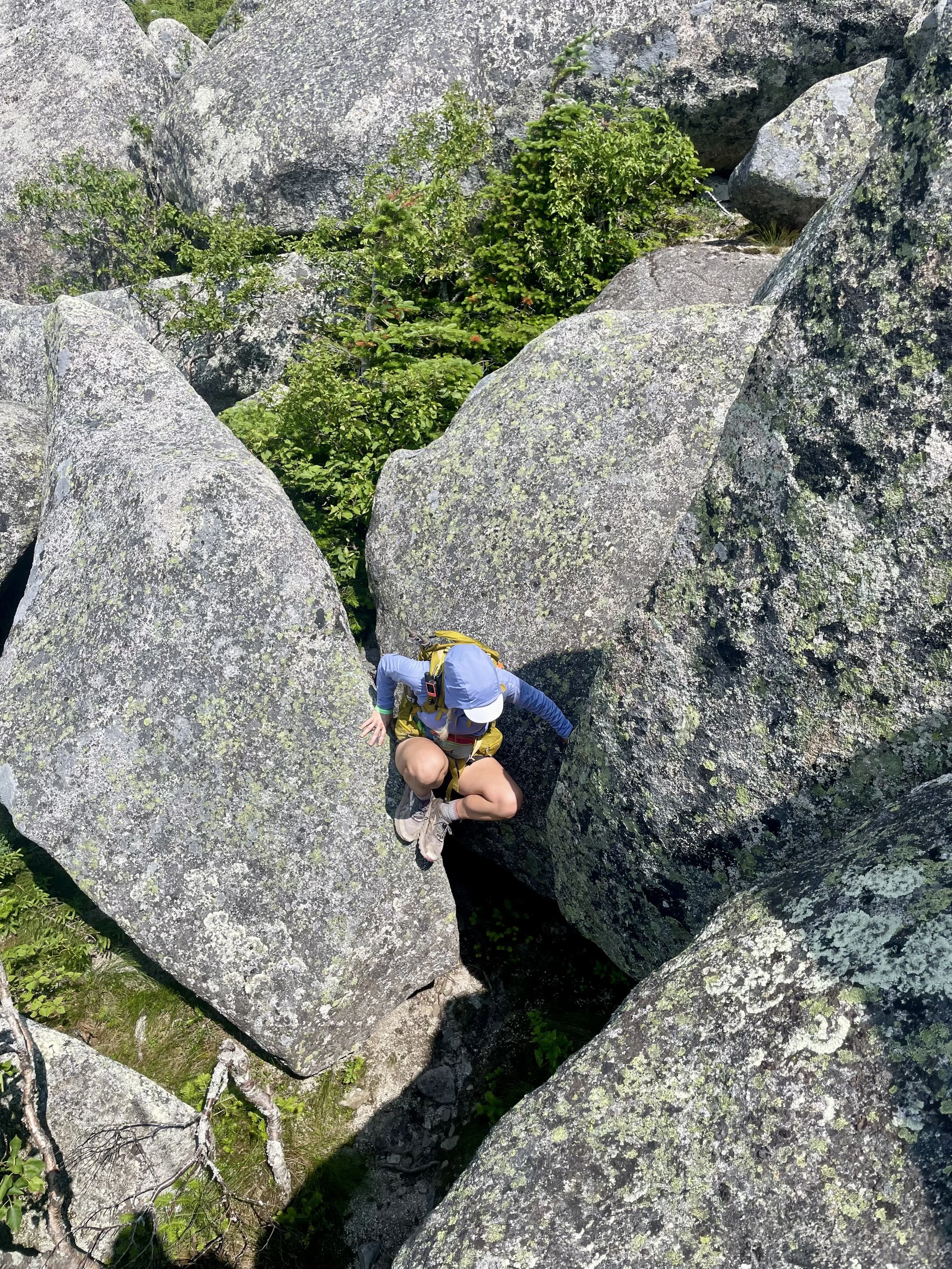
The trail was busy, but George and I slowly chipped away at the elevation gain. The first 40% was in tree coverage and was typical Appalachian Trail stuff so there’s rocks and roots but nothing too technically difficult. When we got out of the tree cover, that’s when it started to get a bit more technical and sincerely bouldering. There were handholds, rebar, and some areas that had us looking around wondering if this was the correct way. Every once in a while, we would get a glimpse of a White Blaze, which would confirm that - even though it is my last day on the Appalachian Trail - the Appalachian Trail still is delivering comedic routes. It was in this section that I was very thankful that I had a lighter pack.
One funny anecdote is that there was a group of six early-20s men who were all shirtless out for a day hike. We kept leapfrogging them because they would go out sprinting up these climbs and then have to stop to catch their breath. All the while George and I were just slow and steady, but continuing to move. At one point, the obvious leader of the group said to the group of guys “Let’s keep ripping it boys”. And this is one of George and my favorite quotes to this day.
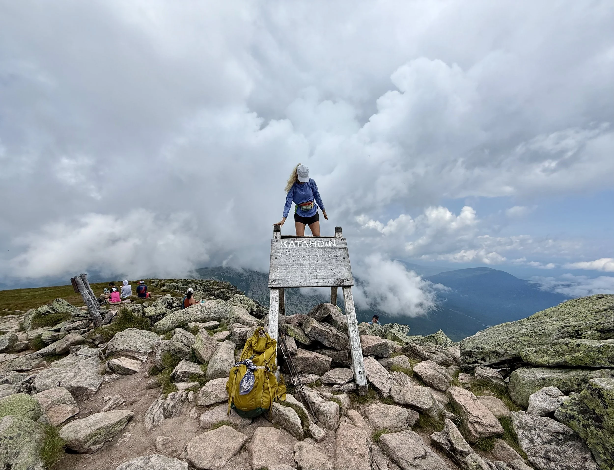
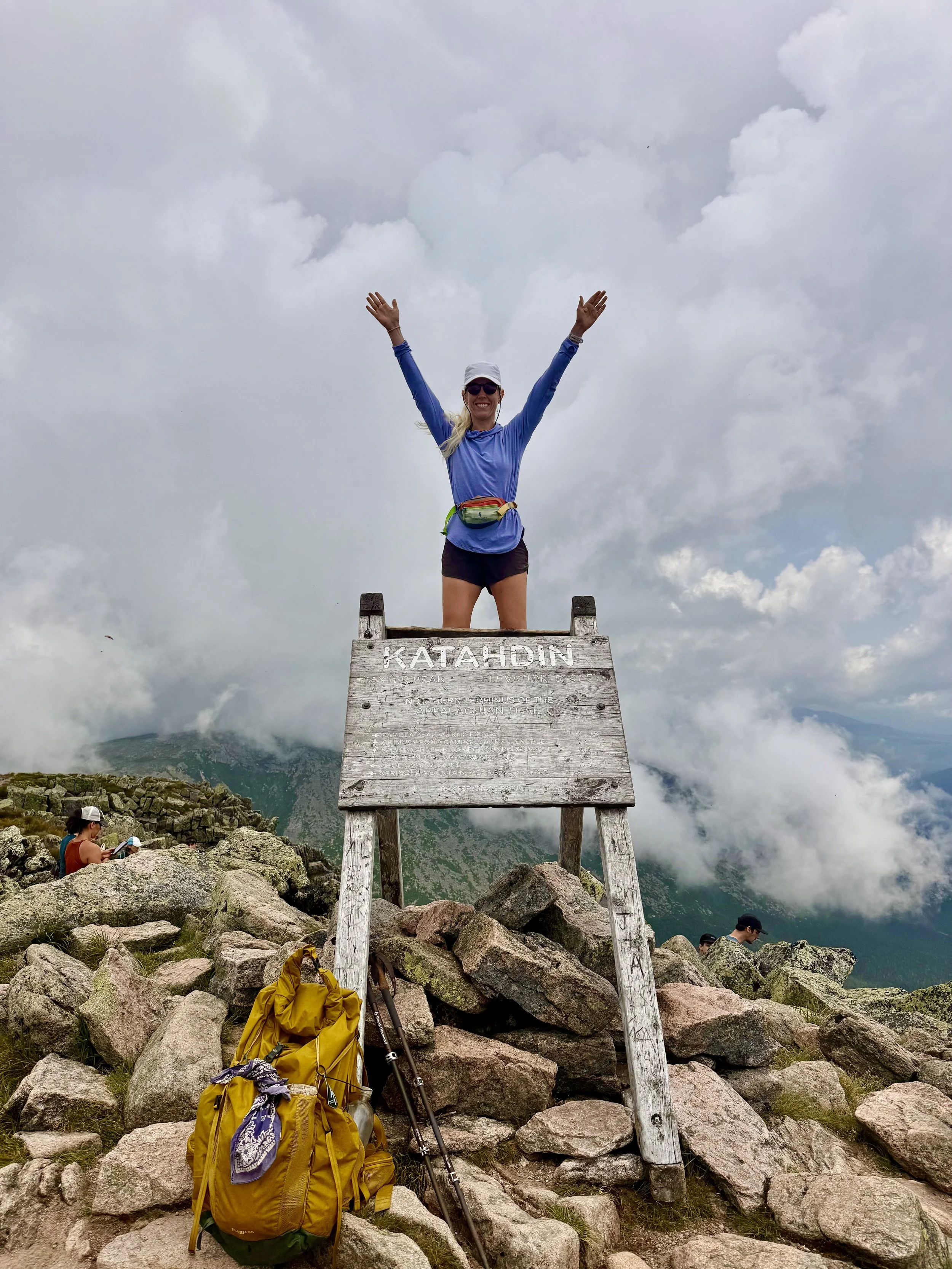
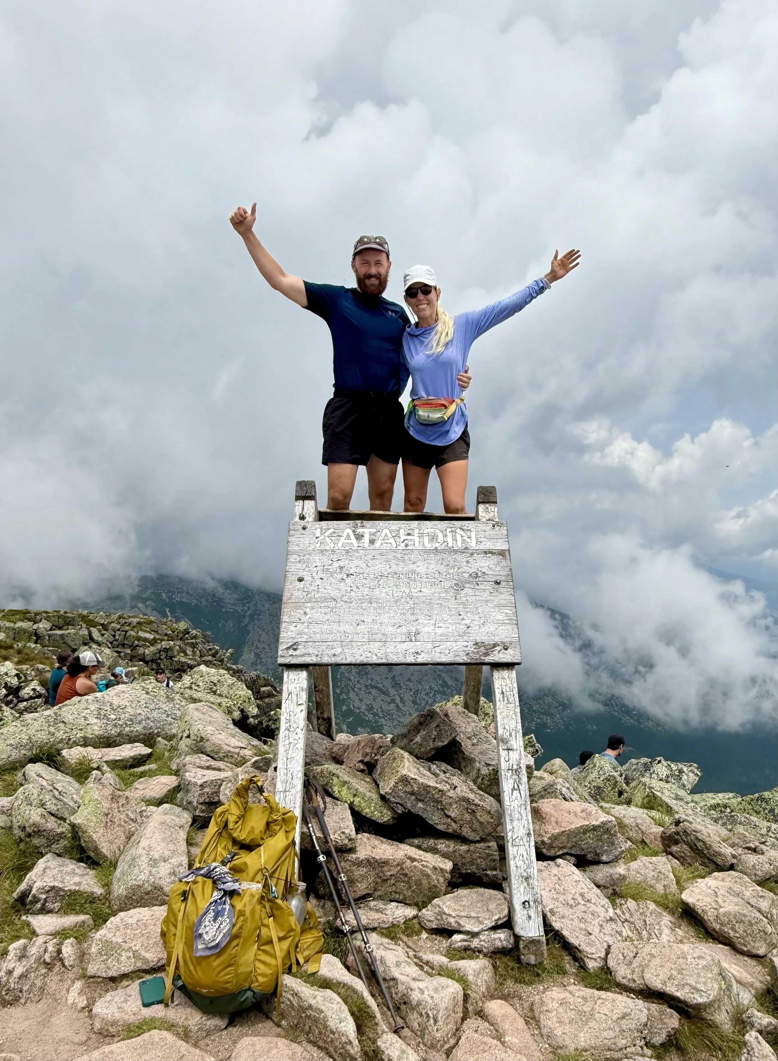
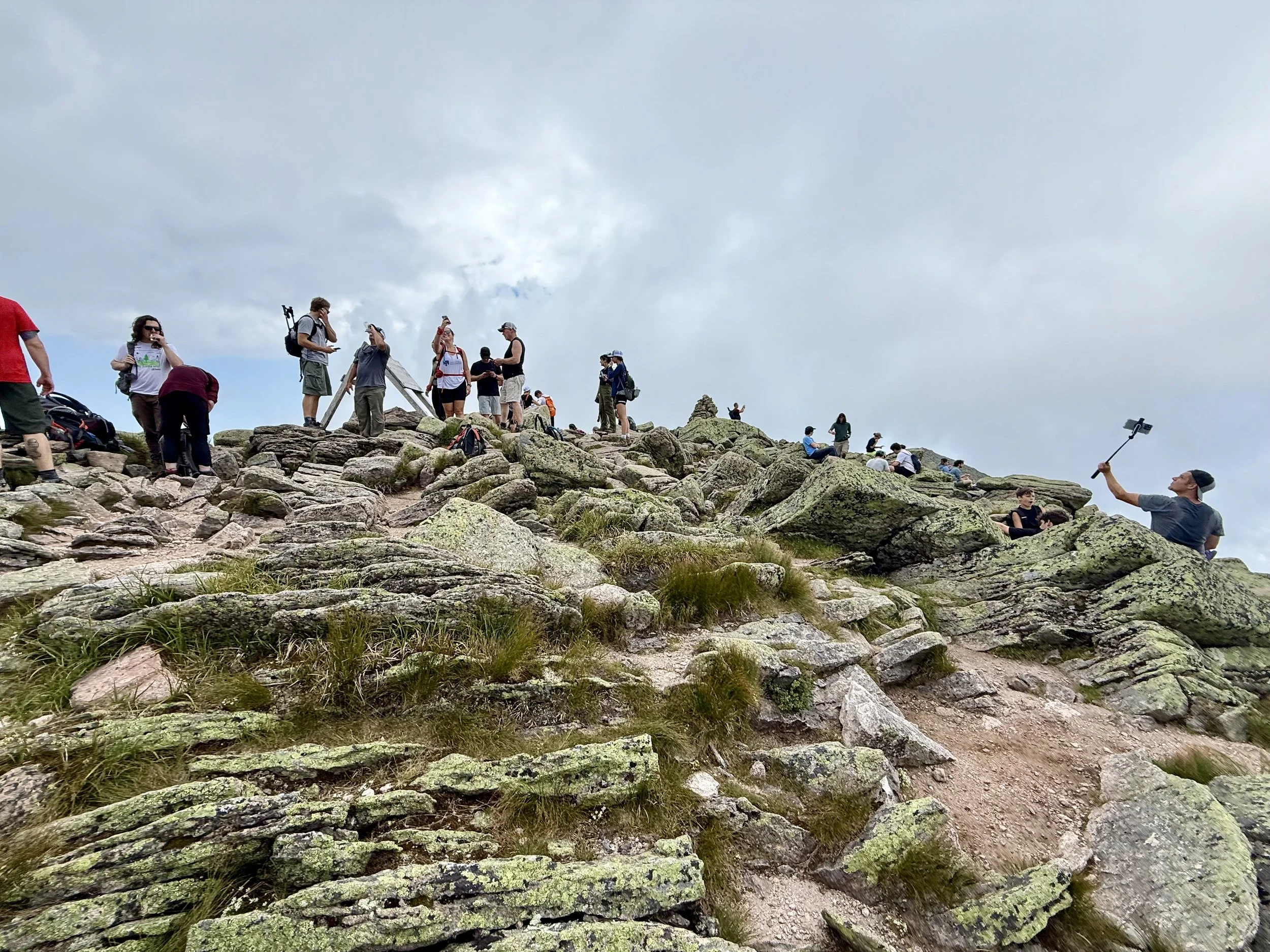
Once over the technical rock climbing section, it was a pretty gentle grade to get to the actual summit. I could see there was a large group of people at the top, which was where the famous Appalachian Trail sign was.
Unless you have done it, there’s no real way to describe what it feels like to approach the finish line of an over 2000 mile race. I know that this was day 103 for me, not my 100 day goal, but it still felt like this race was in fact, 103 days. I always had a timeline in my head. I was doing math of what daily mileage looked like and to see the finish line – that sign – it was a surreal experience. When I got to the top and was near the sign, I started crying. There was at least three dozen day hikers up there, and there was a queue for the sign to take a picture with it. Some people were looking confused as to why I was overcome with emotion, but then they saw the Appalachian Trail hang tag on my pack and realized that I had walked from Georgia.
George and I waited for the queue to take pictures with a sign to go down, but it never really went down so I waited in line. We took a few photos with it and the people at the top gave us a round of applause. It was a full circle moment to be there with George, who I met on night one at Gooch Mountain shelter, 102 days ago. You never know who you are going to meet on these hikes so going into the experience with an open mind of who you will meet or who you will become is imperative.
There were so many people that kept flooding into the top of Mount Katahdin, that I got no videos and only limited amount of pictures because there was such a line formed at the sign. This was in direct contrast to my experience at the northern terminal of the Pacific Crest Trail, where I had it for 30 minutes by myself. So my summitting and ending the Appalachian Trail felt like the rest of the Appalachian Trail to me – a bit rushed.
We had lunch at the top of the mountain and then started our head our way back down. In true Appalachian Trail form, the ending was not easy and we had to do the exact same thing as we did on the way up in order to get back down to the campsite.
The rock climb down went slightly faster because we knew the routes. When we arrived back down at Katahdin Stream campground, we were hoping for a hitch back to Abol Bridge. But the roads are configured strangely in the area and that that would’ve been actually a 30 minute drive so we were not hopeful that we would get one. The campground store closed at 6:00pm so George made a valiant effort to run the last 5 miles of the day in order to get back to get some snacks. This last 5 miles was probably one of the hardest 5 miles of the trail for me because I was officially done and ready to be done hiking.
Upon arriving back at my already set up tent, George was waiting with snacks. This was a surreal moment of realizing, “Well I don’t have to hike tomorrow.”
And just like that I finished the Appalachian Trail.
But…
Now what?